Smaller campus additions ending, beginning

The Dartmouth reported that the New Hampshire Hall project is ending.

The Buchanan renovation is going ahead. For a short time, the project page seems to have included a rendering of the glassed-in hyphen that will connect Buchanan to Woodbury House.

In town, the Valley News notes that the foundering hotel proposed for the corner below the Post Office might be taken up by a new developer.

Wheelock Mansion House — Owned by Dartmouth?

Dartmouth’s Real Estate office is now renting out Eleazar Wheelock’s Mansion House on West Wheelock Street. Until recently, the house was a flower shop not owned by the College, and Dartmouth even turned down a sale offer in the early 1990s. Does this mean Dartmouth has acquired the house?

The rear addition of brick, built for the Howe Library stacks, is a separate rental unit.

Dartmouth might sell its interest in the Water Works

The Valley News reports that Dartmouth College is considering the sale of its nearly-53 percent share in the Hanover Water Works Company, Inc. to the Town of Hanover, which owns the rest of the company.

College towns are typically dominated by their colleges, but having a college share control of the municipal water company seems unusual, if not unique.

In the 1890s, President Tucker pushed Dartmouth to establish the Water Works and the (College) Heating Plant as companion infrastructure projects.

Conservation easement in Corinth

A press release notes that Dartmouth received 700 acres of forested land in Corinth, Vermont, in the 1920s. The property, about 35 miles away, has been the source of timber used in College construction projects, including the McLane Family Lodge at the Skiway. The College recently conveyed to the Upper Valley Land Trust the right to develop the property extensively; some logging will continue.

Machado & Silvetti revise Arts Center design

New renderings of the Visual Arts Center have appeared on the Project Page. Where an early page by the firm stated an area of 80,000 square feet, and articles accompanying the initial renderings pegged the building at 96,500 to 99,500 square feet, the “revised program analysis,” surprisingly, identified a need for more area rather than less: it’s now at 105,000 square feet.

The November renderings show a building that seems to have the same basic form and numbers of bays as before. The renderings include plans for the first time. The idea of ground-level retail does not seem to have survived, but the artist-in-residence gets a fantastic perch in the lantern above the campus-side entrance.

Elevation drawings also emerge for the first time, along with contextual views from Lebanon Street and a site plan and photo of a model showing the plaza framed by Spaulding.

There are also images of a sectional model of the arts forum, which is the atrium close to the Lebanon Street entrance, and other views.

This building should look expensive.

[Update 01.10.2009: Two watercolors by Jeff Stikeman have been added.]

Economy slows hospital expansion too

The Valley News reports that the outpatient surgery center (2008-2010) is going ahead but confirms that the Koop Medical Science Complex is on hold.

The November 13 letter from Barry Scherr and Adam Keller (pdf) stated: “We will complete planning already under way for projects which would then require additional financial resources before proceeding to the next phase: Class of 1953 Commons and the C. Everett Koop Medical Science Complex.” The three-part complex planned for the south end of the hospital is shown in a November 3, 2006 announcement and is explained in detail on its capital campaign page.

—–
[Update 01.05.2013: Broken link to campaign page removed.]

South Block redevelopment finished

The Dartmouth reports on the completion of this large project, and Willy Black comments positively in the CV Spectator.

Construction on the hotel going in south of the Post Office (north of Umpleby’s on South Street) will begin in 2009. The building will have an underground garage.

—–
[Update 03.31.2013: Broken link to Olympia hotel info removed.]

South Block and the neighborhood

Dartmouth’s Real Estate Office is finishing 68 South Main, the most prominent building in the South Block project. Its neighbor, the frame building in the drawing, is number 72.

The latest rendering of the hotel planned for South Street is an improvement over the plainer, more prefab first version.

“The Chimneys,” Ledyard Bank’s building at 2 Maple Street, is finished.

—–
[Update 01.13.2013: Broken link to Olympic Companies rendering removed.]

Hanover High landswap revisited

Although Dartmouth’s proposed acquisition of the high school would have deprived the town of an important element, it would have given the College a large tract of land very close to the campus. Part of the property was already in the form of sports fields, and the high school itself always seemed like it could make a good rugby clubhouse. The swap did not go through.

An unreleased proposal from a few years ago shows that someone was at least thinking of using the property for a new baseball field (putting something like Biondi Park there would have allowed Centerbrook to expand Alumni Gym) and, more interestingly, for faculty or graduate student housing. The ranks of buildings were to stand next to St. Denis Church.


excerpt from Bagnoli presentation

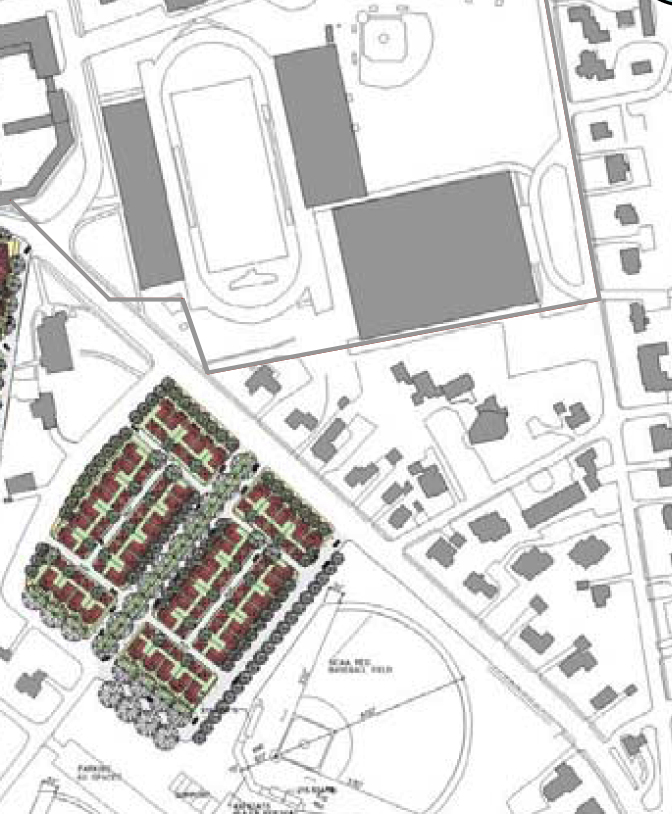
Excerpt of plan from Bagnoli presentation

The plan appears in a 2007 presentation (pdf) by architect David Bagnoli of the Washington, D.C. firm of Cunningham | Quill and might have been created by that firm.

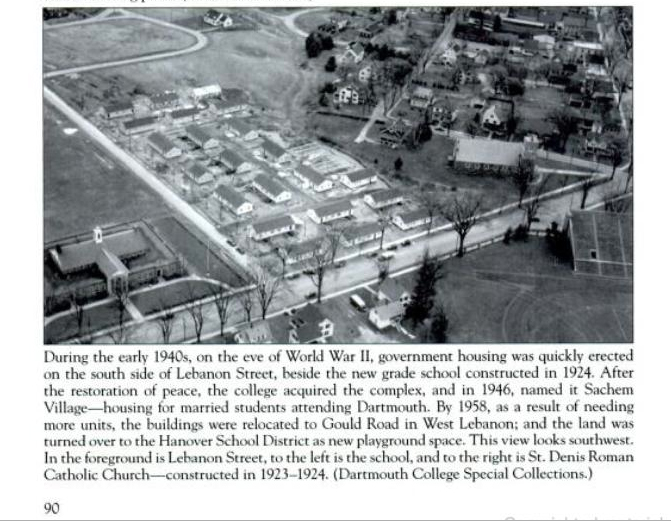
What is most remarkable about this plan is that it nearly replicates a housing development that once stood on the same site, the wartime Sachem Village (it was the precursor to the present Sachem Village). A nice aerial of this original Sachem Village appears on page 90 of Frank Barrett’s latest book, Early Dartmouth College and Downtown Hanover.


thumbnail from Barrett (2008)

Thumbnail of portion of page 90 in Early Dartmouth College and Downtown Hanover

—–
[Update 11.17.2012: Broken links to images fixed.]

Interesting future projects

References to these still-vague proposals appear in Dartmouth’s recent master plans:

  • The Hanover Bypass: A new interchange for Interstate 91 south of Norwich would send a new bridge across the Connecticut, leading to a road through the woods to Route 120 near the DHMC. This would allow hospital and Lebanon traffic to avoid the corner of Main and Wheelock. Dartmouth and the hospital own most of the land along the route, which lies in Lebanon, and seem likely to favor a bypass. The Town of Lebanon does not appear to favor it.
  • The Bartlett Hall Addition: An extension to the east, at least, toward the Sphinx, would occupy a site with plenty of room, some of it a vacant lot left by Culver Hall. The road could be eliminated or moved eastward. Bartlett is extremely distinctive and picturesque, and any addition would have to answer the question of style right away.
  • College Park Gates: this idea is from Saucier & Flynn’s landscape master plan. The College Park once had a design language of its own, although it is difficult to tell whether it was more Victorian iron curlicues or Victorian bark-covered sticks, as in the Adirondacks. At any rate, College Park does not seem like a red-brick Georgian place. The plan also suggests bringing College Park down to Wheelock Street, at least by reference. It would be nice to connect the Sphinx, which seems like an island, to the park itself.

[Update 10.10.2008: Replaced Route 10A with Route 120.]

No hope for a “Boathouse Row”

A lot of river-related planning activity has focused on the Fullington Farm/Chieftain Inn area north of campus recently.

Although the Upper Valley Rowing Foundation seems to have settled on a site closer to Wilder Dam for its future boathouse (design by U.K. Architects), its past meeting minutes have mentioned an interest in buying Fullington Farm, or at least a right to use part of it, from Dartmouth. Now the Friends of Hanover High Crew have signed an agreement with Dartmouth and plan to build a community boathouse on the farm (UVRF May 2008 minutes pdf).

Fullington Farm is the site of the Dartmouth Organic Farm and might be the location of the Lyme Road site that is occasionally proposed as a new home for Thayer School (see 2002 Master Plan, 14 pdf).

At the Chieftain, Black Bear Sculling runs a sculling program. Now the Chieftain is requesting a zoning variance to allow a private club on the property (Zoning Board of Adjustment July 10, 2008 pdf). The zoning board minutes do not indicate the purpose of the club or whether it has anything to do with rowing.

—–
[Update 11.11.2013: Broken link to the Chieftain removed.]
[Update 12.02.2012: Broken link to Chieftain fixed and broken link to Zoning Board minutes removed.]

Campus and area architecture news roundup

The designs for Memorial Field’s West Stand or the replacement for Thayer Dining Hall have not been revealed, but a few smaller items of interest have come out over the past few months:

  • Construction of the ’78 Life Science Center began in early September, notes the OPDC, after the Occom Pond Neighborhood Association’s appeal of Hanover’s zoning permission was dismissed (press release). A webcam shows the site when it’s light out.
  • The reconstruction of Rolfe Field and the construction of the surrounding Biondi Park have been delayed by site conditions, quoted Jim Hunter of Clark Construction Company: “Dartmouth is just so old that you never know what you’re going to
    find underneath the ground.” When students were digging trenches in the area during World War I, they found an old house foundation.

  • Moore Ruble Yudell has a page up for the North Campus master plan.
  • A huge amount of effort has gone into building a sprawling housing development near the hospital at Gile Hill, and into making it not seem like affordable housing (site map). The project was designed by Gossens Bachman Architects of Montpelier, designers of the Rock of Ages Corporation Visitor Center and of a design for the Vermont Granite Museum.

—–
[Update 03.31.2013: Broken link to Gile Hill plan and site map removed.]
[Update 01.05.2013: Broken link to master plan replaced.]